Project structure
The Delta-ENIGMA infrastructure comprises a coherent program of:
- A backbone observation network in a long-term (10-year) deployment at key locations across rivers, estuaries and beach-dune systems. The instruments will measure the slow but cumulative processes during normal and extreme conditions.
- A rapidly deployable set of specialized instruments, to cover floods, droughts and storms.
- Advanced laboratory facilities for experimental biomorphological process studies, to study events and conditions that are presently unobservable in the field.
- A coherent open database of the measurement results, accumulating over the 10-year period, that will support modelling studies and experimental approaches.
- A Productive Knowledge Interaction Facility to boost interactions between biogeomorphology experts, policymakers and delta managers, to quickly bring our new insights to the world.
Delta-ENIGMA consists of five work packages (WPs) with observational/experimental components, and three supporting work packages for data handling, enhancing interactive knowledge production and coordination.
WP1. Sustained high-resolution field observations in rivers
WP1. Sustained high-resolution field observations in rivers
Responsible partner: WUR (Prof dr. A.J.F. Hoitink)
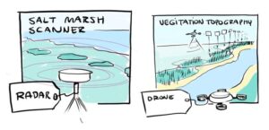
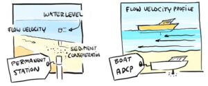
The core of the observation infrastructure for the river stem consists of three continuous monitoring stations that complement the existing monitoring station at Lobith, where the River Rhine enters The Netherlands. The locations are planned in the Upper Merwede, close to the tidal limit, in the Lower Merwede tidal river, and in the New Waterway near the outlet, where flow is highly stratified. At each of these stations, an array of instruments will be installed to collect horizontal profiles of velocity and suspended sediment, based on acoustics at multiple frequencies, optical monitoring and water sampling. Two key river bifurcations and two key tidal channel junctions will be subject to a periodic survey program with multiple ships, to monitor flow, bedload and suspended load sediment transport, grain size information of bed samples and suspended sediment, and salinity profiles at the junction where salt intrudes. The research infrastructure and periodic monitoring program is fully complementary to the existing monitoring network maintained by the Dutch water authority Rijkswaterstaat, which is strongly focused on water levels and discharge.
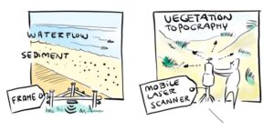
The sustained observation program of floodplains will focus on documenting vegetation dynamics, surface topography and floodplain water bodies. This will be done in contrasting areas, ranging from floodplains with active nature restoration and intensive channel-floodplain interaction to more isolated floodplains with commercial agriculture, and from upper reaches to the downstream, tidally influenced delta. The sustained observations will yield detailed long-term biogeomorphologic development data in the floodplains, and provide essential ground-truth and reference data for satellite-born multispectral remote sensing and national LIDAR height data from plane-borne surveys.

WP2. Sustained high-resolution field observations in estuaries
WP2. Sustained high-resolution field observations in estuaries
Responsible partner: NIOZ (Prof. dr. T.J. Bouma)
Intense long-term observations will focus on the intertidal area in the transition from channel onto the salt marsh. Two contrasting sites will be observed: a sheltered managed realignment site where vegetation expansion is expected but has not yet occurred, versus a wind-swept high-dynamic site with a broad flat-marsh transition. The measurement activities will be concentrated on deploying frames for hydrodynamic forcing and sediment transport rates in the water column, on landscape-scale topographic dynamics and developments, and on biotic developments in vegetation and benthos (sediment-dwelling animals and microbes) on the tidal flats. Regular 13 hours ship-based transects will supplement the measurements on the tidal flat with channel observations on sediment transport and sediment properties.
WP3. Sustained high-resolution field observations on beaches and dunes
WP3. Sustained high-resolution field observations on beaches and dunes
Responsible partner: UT (K.M. Wijnberg)
The long-term observations focus on the physical and bio-geomorphological processes that result in dune building and growth. Identical instrument packages will be deployed at three sites where human interventions have contrasting impact on the cross-shore range over which the wind can transport beach sand onshore and hence impact beach-dune interaction and bio-geomorphological evolution. Site 1 is a wide nourished beach fringed by a tall, uniform and densely vegetated ridge of sand. This site has an ample sand supply but aeolian transport on to the ridge is purposely prevented because it represents a nuisance to the tourist function of the ridge. Site 2 is a natural beach with buildings at the beach-dune transition. Aeolian sand transport on the foredune is possible but is affected to an unknown extent by the buildings. Site 3 is a natural beach where artificial blowouts have been created to stimulate an efficient sand transport pathway from the beach well on the backdunes. At all sites the following activities will be deployed to measure the critical processes for dune formation and stability:
- Topography and bathymetry observations, using 3D laser scanning, a video imaging system and regular ground-truthing with jet-ski surveys.
- Collection of physical process data from beach to dune, through sediment sampling surveys and deploying a weather station on the upper beach.
- Measuring Vegetation dynamics and bio-geomorphological interactions using vegetation cameras, Groundwater-, soil moisture- and salinity sensors, drone surveys, and detained sampling vegetation quadrants, for ground truth vegetation data.
WP4. Observation of extreme events
WP4. Observation of extreme events
Responsible partner: TUD (Dr. B. van Prooijen)
Extreme events such as storms, droughts and floods play a key role in the morphodynamic evolution of deltas. High floods due to extreme river discharges (e.g. Meuse, 2021) or extreme storm surges (1953 coastal floods) not only pose a safety threat, they also reshape the landscape. In the various deltaic systems, the morphological effect of extreme events depends on the local bathymetry or topography, the spatial distribution of vegetation and the specifics of the storm or flood. These effects cannot be extrapolated from normal conditions. This is especially the case if positive feedback loops develop during the events: intense changes in the bathymetry during the event, in turn change the further effect of the event on the morphology. Understanding of flow, wave and sediment transport patterns during events is therefore needed. To capture these, a mobile set of instruments is proposed to measure during events and where possible/needed before and after events.
The set of instruments will consist of frames for measuring hydrodynamics and sediment transport during events as well as instruments to map (changes in) topography and bathymetry. These data will complement the data obtained from the permanent installations.
As different delta systems face different types of events and conditions, and as the topographies and bathymetries are different, tailored measurements will be carried out. Where possible, instruments are shared. This is the case for the pool of 12 mobile frames, shared between observations in estuaries and river floodplains, and for the LIDAR drone and backpack laser scanner, of which a single instrument will be used in all three systems.
WP5. Laboratory equipment for process studies
WP5. Laboratory equipment for process studies
Responsible partner: UU (Prof. dr. M.G. Kleinhans)
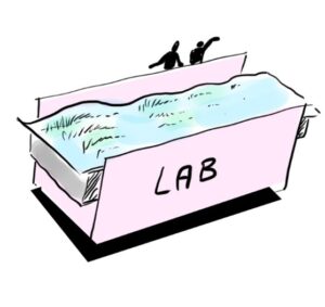
The Delta-ENIGMA field facilities will provide data on time/space variations of sediments and sediment transport processes. The scientific objective behind the collection of these high-resolution data is to improve the modelling and predictive power of delta development in times of change. An essential step here is linking observed patterns in the field with concepts and knowledge translated into functional relations used in modelling. As an intermediate step in this translation, experimental approaches, in which single factors are varied and their influence on sediment dynamics precisely determined, are indispensable. While the partners in this proposal all have existing laboratory facilities that are intensively used for this type of studies, these facilities are isolated and not sufficiently connected, which limits their impact. Within Δ-ENIGMA, we will push these facilities to the next level and establish a truly national infrastructure. By making selective investments in the equipment base of the existing facilities, they will be made more congruent in the data they deliver.
Investments will be made in:
- Facilities for sediment tracing:
- Sediment tracing by luminescence (WUR). Extending current methods with new promising developments based on the detection of feldspar infrared photo-stimulated luminescence signals (IRPL).
- Sediment tracing by geochemistry (UU).
- Sediment tracing by grain size analysis (TUD) using Camsizers and optical grain microscopy.
- Flume facilities for sediment transport and biogeomorphology studies. Upgrades and new investments:
- Current Flume (WUR) for analysis of sediment transport in rivers, with acoustic velocity profilers and a Particle Image Velocimetry (PIV).
- Wave Flume (TUD), to study sediment transport under wave processes with weak currents, now with a true sediment floor.
- Wind tunnel (UT) to investigate the role of variable soil-moisture levels on the initiation of sand transport.
- BioLiveFlume (NIOZ) to study living biota under different salinities and wave-flow conditions.
- Metronome (UU) for experiments on systemic effects of physical and biological processes and their boundary conditions (including subsidence) on the development of entire estuaries.
- Global change mesocosms for intertidal estuarine conditions, and for dune vegetation.
WP6. Productive Knowledge Interaction (PROD) Facility
WP6. Productive Knowledge Interaction (PROD) Facility
Responsible partner: Deltares (G.-J Ellen)
Delta management involves dealing with inherent scientific uncertainties on the one hand, and complexity of stakeholders and their interests on the other hand. In this complex landscape, it is not sufficient to ‘communicate’ scientific findings as an end-of-the-pipe and one-way activity. Empirical evidence shows that active involvement of non-academic stakeholders with their experience and practical knowledge at different stages of knowledge creation, promotes the real-world relevancy of research outcomes. These are coined ‘productive interactions’, where ‘productiveness’ is determined by the efforts of stakeholders to change behavior and apply research results to social goals. In the current practice of river, estuarine and coastal science in the Netherlands, intense science-practice networks are established in NCR and NCK, but although this provides an extremely valuable tight network of scientists and practitioners, the knowledge uptake/valorisation approach is intuitive and has inherent limitations due to the low level of sophistication in the communication of often very complex concepts and models. At the same time, existing advanced communication infrastructure at TUD (Gamelab), WUR (WANDER-LAB), UT (DesignLab) and Deltares (iD-Lab) is currently under-used for knowledge interaction in the field of delta management. The PROD Facility will connect these individual facilities into a national network, allowing each of them to specialize in one aspect of productive knowledge interactions but basing them on a common communication and data backbone. This will, in addition, provide a joint facility for active social science research into improvement of productive science-science and science-practice interactions.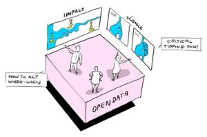
WP7. ICT backbone for FAIR data management
WP7. ICT backbone for FAIR data management
Responsible partner: Deltares (G.-J. Schotmeijer)
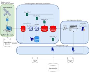
Collecting, storing, aggregating, documenting and distributing the vast amount of data that will be generated by the Delta-ENIGMA infrastructure, is a key objective of the system as a whole. Following open science and FAIR principles, the main principles of the data-infrastructure are:
- Data gained by the observation activities will be centrally stored in the Delta-ENIGMA data base (Data Storage Layer). Data generated by the labs, including the PROD facility, will be stored locally because usually extensive data gathering and storage facilities are already in place for the labs. Data underlying any publications from these lab studies will be distributed through the Delta-ENIGMA website.
- All data stored will be extensively documented in a metadatabase, following rules and conventions of SeaDataNet (https://www.seadatanet.org). These metadata will be searchable through the data portal, and will guide users to the downloadable data sets (Data Exploration Layer).
- The Delta-ENIGMA database will be linked to databases holding other data of importance for the analysis of Delta-ENIGMA data (e.g. Rijkswaterstaat monitoring data) and to the DANUBIUS-RI data system (Data Federation Layer).
- The ICT architecture will make maximal use of existing infrastructure, e.g. SURF (https://www.surf.nl/en), and existing systems for FAIR retrieval of data (e.g. SeaDataNet).
- A uniform open-source package will be developed with which data from all Delta-ENIGMA instruments can be read out, quality-controlled, documented with metadata, packaged in uniform data structures, and uploaded to central storage.
WP8. Project Governance
WP8. Project Governance
Responsible partner: UU (Prof. dr. B.G. Ruessink)
The programme management is led by Utrecht University. The management teams are formed by representatives from all partners.
